Moscow-Washington DC mashup

The history of the urban development of the capital of the United States and the capital of Russia is a very different one. Washington DC is a planned city, with its core consisting in a straightforward street grid oriented to the four cardinal directions, with some diagonals avenues. On the other hand, Moscow has gradually expanded from the Kremlin, the medieval fortified citadel, that is the centre of a radial urban developement made of concentric circles.
Over the centuries, the Moscow Kremlin has consolidated its role as administrative centre of an increasingly complex and influential nation, eventually becoming the symbol of the state power of the Soviet Union, during the years of the Cold War. A similar metonym identifies the Pentagon, the headquarter of the US department of Defense, with the department’s leadership. For this reason, in the popular discourse, the symbolic contrast between the two sites was often used to represent the tension between the two conflicting superpowers.

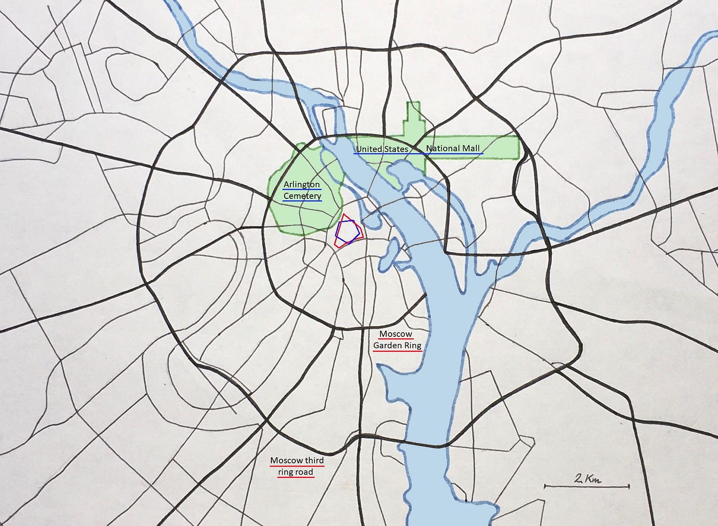
The opposition between the United States and the Soviet Union, as well as the opposition between the ideological systems that the two countries represent, do not need any explanation. In the map above the sites of the Pentagon and the Kremlin coincide. At the centre of the map, a blue line identifies the perimeter of the Pentagon, while a red line identifies the perimeter of the Kremlin.

Whereas the Kremlin is the unequivocal centre of Moscow, the Pentagon is situated off centre with respect to Washington DC, and it is formally part of Arlington, in the state of Virginia. Pinning the location of the Pentagon and the Kremlin together when overlapping the maps of the two capital cities implies that the most emblematic sites for the celebration of the American democracy are mostly situated north-east of the centre of Moscow. The US Capitol building in particular, for its location at the east end of the the central green promenade known as National Mall in DC, would be located in close proximity to the third ring road of Moscow city (in the map only the second and the third are clearly recognisables). Let’s give a closer look to some of these emblematic American sites in comparison with the muscovite counterparts that correspond to them on the map.


Let’s now turn to some of the iconic landmarks of the former socialist superpower, and see what landscapes in Washington DC correspond to them in the map…


State intervention plays a crucial role in urban planning in socialist countries. Whereas the suburban sprawl made of detached small houses with gardens describes much of the American urban landscape, apartament blocks with much more impressive proportions generally characterise the environment of Moscow and other Russian cities.
Moreover, since the 50s, the landscape in Moscow has been dominated by seven skyscrapers known as Seven Sisters, that are some of the most reknown examples of Stalinist architecture. The next pictures constist of imaginary landscapes where some of Moscow Seven Sisters are integrated into the landscape of The Washington DC area that would correspond to their immediate surroundings on the map mashup. An imaginary aerial landscape including a famous circular apartament building in Moscow and the corresponding suburban built environment in the Washington DC metropolitan area completes the picture.


The map below locates most of the sites that were shown in the previous images. Blue for the Washington DC-based places and red for the Moscow-based places.

